Σάββατο 28 Οκτωβρίου 2023
Σάββατο 10 Δεκεμβρίου 2022
Iran Accuses Israel of Cloud Theft: Weather Warfare and the CIA Cuban Rain Embargo
Iran Accuses Israel of Cloud Theft: Weather Warfare and the CIA Cuban Rain Embargo
https://www.youtube.com/watch?v=6qKAccFN3Co
Τρίτη 19 Ιανουαρίου 2021
ΠΩΣ ΣΤΑΜΑΤΗΣΑΝ ΕΝΑΝ ΤΥΦΩΝΑ ΜΕ ΤΟ HAARP
Watch Hurricane Lane Be Destroyed By HAARP-Like EMF Just Before It Was To Hit US Military Bases On Oahu - Photos |
By Jeff Rense |
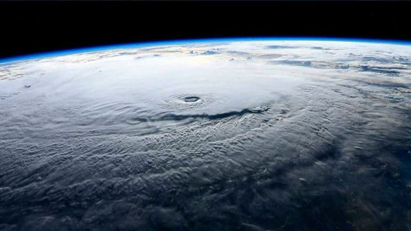
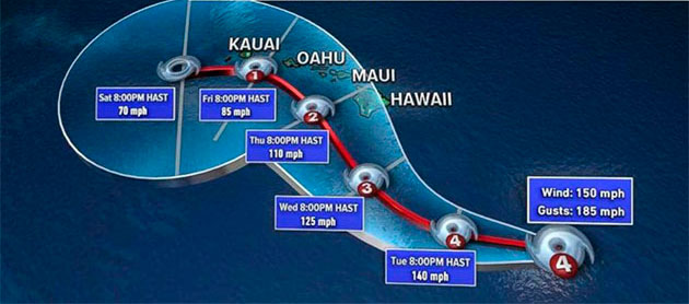
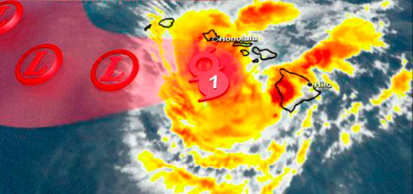
| Like most of us, I have watched hurricanes via aerial and satellite photos all my life. Huge, masses of moisture, wind and POWER spiraling counterclockwise (reverse in the Southern Hemisphere) and often doing enormous damage when these monsters make landfall. How big was Hurricane Lane? How large was the danger posed to the US Military on and around Oahu? It was SO large, there was a highest level US Navy alert and warning issued a couple days before Hurricane Lane was due to slam into Oahu… potentially causing hundreds of millions in damage to military installations which control the entire Asia Pacific theater. The Alert instructed all military personnel to make plans to either get out or to prepare to shelter in place. This was not a joke to US Naval Command. Below is a satellite image of the hurricane with the eye clearly located in the center of the spinning storm with winds of over 150 mph. This meant big trouble for Hawaii military bases and civilian populations alike.
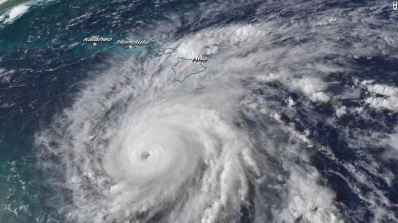
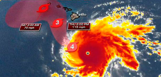
From: COMPACFLT, Subject: Directorate Quarters Notes IMPORTANT INFO FROM NAVY REGION REGARDING HURRICANE LANE ▲ Hurricane Lane is expected to make landfall Friday @ 1500 as a Category 4 Hurricane. Current models have it hitting Hickam Beach directly. ▲ Officials expect (worst case) tidal surges up to 15 feet high on Joint Base Pearl Harbor-Hickam. ▲ We are currently at Topical Cyclone Condition of Readiness (TCCOR) 3. ▲ Expect shift to TCCOR 2 Thursday morning. ▲ Expect shift to TCCOR 1 Thursday afternoon or Friday morning. TCCOR 3: Destructive Winds are possible within 48 hours. TCCOR 2: Destructive winds are anticipated in 24 hours. TCCOR 1: Destructive winds are anticipated within 12 hours. **A more descript breakout of TCCORs can be found in the attachments.** ▲ Those living on base need to ensure they are back on base prior to TCCOR 1 being set, or they will NOT be let on. ▲ Joint Base Pearl Harbor-Hickam (to include Ford Island and NCTAMS) will be locked down during TCCOR 1 and will not reopen until Saturday morning. ▲ The Ford Island bridge will be closed whenever winds reach 50 knots or greater. ▲ Ports of Hawaii are now shutdown (no food, supplies, etc. will come in for upwards of 7 days from now). ▲ Public schools will close after school today (Wednesday). ▲ If you do not have 3 days worth of non-perishable food and water you need to get that tonight. ▲ Should cell/cable/internet services go down, you can get important updates on the radio at 92.3 FM ▲ Those living on base down island should try to park their cars in an elevated parking garage or parking lot. ▲ Expect Command and Operational recalls over the course of the next three days. Keep your phone on you or near you and notify someone if you will be away from your phone for an extended period of time. Here is an overhead photo of the storm showing the Islands clearly in harm’s way. Lane was a textbook classic hurricane if there ever was one.
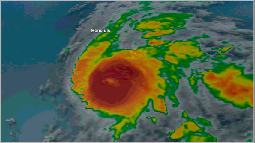
Notice the eye of the hurricane is quite pronounced and surrounded by the150 mph winds powering the spiraling rotation of the big storm.
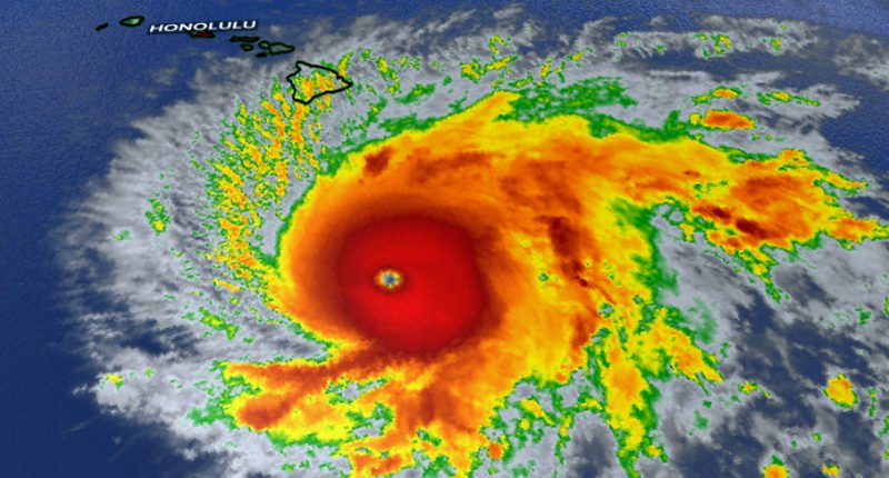
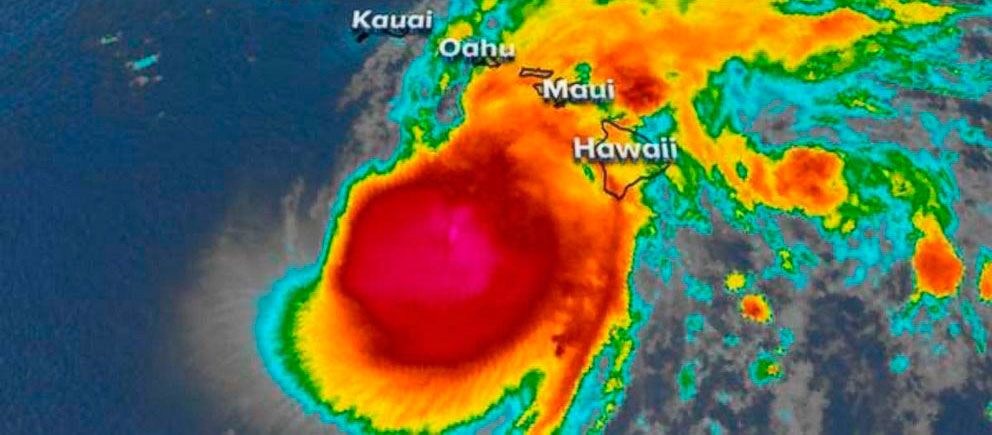
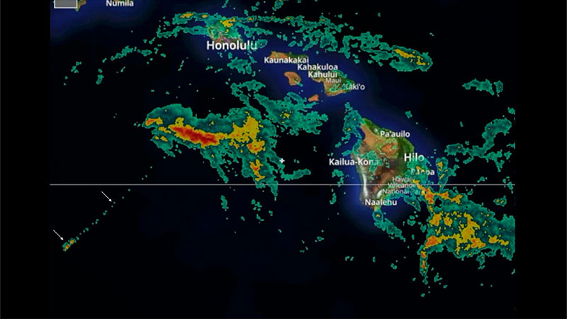
However, note carefully how slow the spiraling rotation of the storm had suddenly become. It was now barely spinning and presents more like a large blob of intense moisture. The eye is nearly gone now. The huge (red-orange) storm continued to crawl straight north, directly toward Honolulu, when something caused it to essentially slow to a near stop immediately south and offshore of Oahu. It was as if it had been parked there just before it would have scored a direct hit on Oahu…exactly like the highest level US Navy Alert warned it would do. The once tightly-defined spinning shape of the hurricane is gone and it is now seen oozing large amounts of moisture up and to the right in the photo…
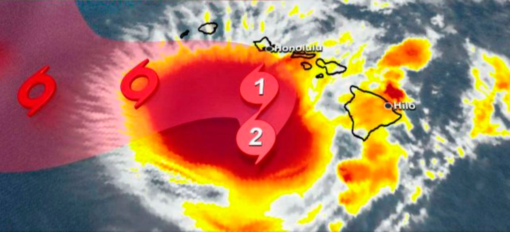
It took a long time and a little luck to find this particular video frame below which shows blatant proof of extreme EMF military-government weather control. Now see what has happened…it was as if a gigantic boot came down right on the top of Hurricane Lane. The ‘boot' was, of course, an electromagnetic GeoEngineered HAARP-like BLAST of EMF which crushed the hurricane to pieces. Have you EVER seen a hurricane suddenly STOP SPIRALING, sit perfectly still and then be smashed with enormous energy from above? Look below…now you have have. Look again at the preceding photo ABOVE and then look back down at the photo BELOW…your eyes don’t lie…
LOOK CLOSELY and you’ll see how these ‘fingers' are shaped exactly like the blade of a saw! That is NOT naturally possible. That is EMF weather control. Further, they are all pointing straight outward at essentially 90 degree angles from the perimeter of the massive amount of moisture (red) the storm was still carrying. Hurricane Lane, like a squashed bug, is no longer showing any signs of spiraling. In fact, the more you look at the bottom left section of the (red) storm center, the more crazy, bizarre things you see! You are looking at the almost instant results of a violently powerful EMF weather ‘bomb’ used, in this case, to destroy a hurricane to protect scores of sensitive, critical military facilities on Oahu. Read the Highest Level US Navy warning again. Apparently, a (Pentagon) decision was made to protect the military nerve center of the Asia Pacific Theater from the potentially major damage of Hurricane Lane…even at the risk of revealing the incredibly-advanced weather control technology the Military and Deep State possess. It was a calculated risk…’they’ were hoping no one would notice the unprecedented and bizarre ‘behavior’ and demise of what had been a Cat 4 Hurricane just 24 hours earlier. This particular video frame proves that our weather is in the firm control of the military industrial congressional media complex. Below is a second look at the same image. Do you see ANY evidence of a SPIRALING HURRICANE? No, none. There is no more spin or spiraling or any substantial wind. The big storm was brought to a complete stop...shutting down the spiraling winds…and then Hurricane Lane was essentially annihilated.
Notice the outer ‘ring' on the left and bottom where the EMF energy cut through the intense red body of moisture of the storm. Where did all the red moisture (rain) go? It probably fell straight down into the ocean below it.
Here now is one final satellite photo in different color mode which shows the crushed, destroyed pieces of Hurricane Lane. This last photo evidence of EMF weather control also reveals a bizarre completely straight line at about the 7:30 position on the clock. Look down to the left end of this ‘clock hand’ and you will see two TINY rectangular rain cells. Not natural. No chance. The USAF boast about ‘controlling the weather by 2025’ is already a done deal. - Jeff Rense
|

WEATHER MODIFICATION ASSOCIATION (about us)

Our Mission
“ Enabling persons, political entities, and other organizations to make informed decisions about the application of weather modification technologies, to provide for adequate water supplies, and reduced natural weather hazards. ”
Our Vision
“Free exchange of accurate information regarding the efficacy, safety, methodology and cost-effectiveness of weather modification activities.”
Association Statements
Our Corporate Members


Σάββατο 13 Ιουνίου 2020
ΑΕΡΟΨΕΚΑΣΜΟΙ ΠΑΝΩ ΑΠΟ ΤΗΝ ΠΑΡΟ
ΣΕ ΦΩΤΟΓΡΑΦΙΕΣ ΟΥΡΑΝΟΥ ΤΡΑΒΗΓΜΕΝΕΣ ΑΠΟ ΤΗΝ ΠΑΡΑΛΙΑ ΤΟΥ ΑΓΙΟΥ ΓΕΩΡΓΙΟΥ ΤΗΣ ΝΑΞΟΥ ΠΡΟΣ ΤΗΝ ΠΑΡΟ...
ΠΑΡΑΤΗΡΗΣΑΜΕ ΕΝΑ ΠΛΕΓΜΑ ΠΕΝΤΑΚΑΘΑΡΑ ΝΑ ΦΑΙΝΕΤΑΙ ΠΑΝΩ ΑΠΟ ΤΗΝ ΠΑΡΟ


woodiiis
ΠΑΡΑΤΗΡΗΣΑΜΕ ΕΝΑ ΠΛΕΓΜΑ ΠΕΝΤΑΚΑΘΑΡΑ ΝΑ ΦΑΙΝΕΤΑΙ ΠΑΝΩ ΑΠΟ ΤΗΝ ΠΑΡΟ


(κλικ στις εικονες για ζουμ)
woodiiis
Δευτέρα 30 Οκτωβρίου 2017
Η ΝΑΣΑ παραδέχθηκε εμμέσως πλην σαφώς το “Πρόγραμμα Ασπίδα” για το οποίο μας ψεκάζουν
Η ΝΑΣΑ παραδέχθηκε εμμέσως πλην σαφώς το “Πρόγραμμα Ασπίδα” για το οποίο μας ψεκάζουν

Μια σύντομη εισαγωγή για να κατανοήσετε καλύτερα την ανακοίνωση της ΝΑΣΑ:
Όπως έχουμε ξαναγράψει, η έρευνα μας σχετικά με τη χρήση χημικών αεροψεκασμών και ηλεκτρομαγνητικών συστημάτων, πάει δεκαετίες πίσω, στα χρόνια της Σοβιετικής Ένωσης, πριν την υιοθετήσουν οι Αμερικάνοι.
Ο αρχικός σκοπός των Σοβιετικών ήταν με τους ψεκασμούς, να δημιουργήσουν μια “ομπρέλα” πάνω από τη χώρα τους που θα έκοβε την πρόσβαση εχθρικών πυραύλων, αλλά επίσης να πάνε τις επικοινωνίες ένα βήμα πιο μπροστά με την τεχνολογία Τέσλα, ειδικά τις υποβρύχιες. Οι πληροφορίες αυτές επιβεβαιώνονται από πολλές πηγές, το δε όλο πρότζεκτ ονομαζόταν “Πρόγραμμα Ασπίδα”.
Το στρατιωτικό αυτό πρόγραμμα των Σοβιετικών ήταν για καθαρά αμυντικούς σκοπούς, δεν έχει καταγραφεί καταγγελία παρέμβασης στο περιβάλλον ή χρήση του προγράμματος ως όπλο, πλην κάποιες νύξεις ότι το δικό τους χααρπ, ο “Τρυποκάρυδος”, ίσως έκανε πειράματα ελέγχου του νου στους Σοβιετικούς.
Μετά την Περεστρόικα, όταν οι περισσότεροι επιστήμονες είχαν φύγει για ΗΠΑ γιατί δεν μπορούσαν να έχουν δουλειά στη χώρα τους, εμφανίστηκαν και οι πρώτοι χημικοί αεροψεκασμοί στις ΗΠΑ, ενώ το 1992, εγκαινιάστηκε το χααρπ.
Τώρα, αυτό που λέμε είναι ότι οι συνεχείς ψεκασμοί που γίνονται σχεδόν παγκόσμια, ουσιαστικά έχουν βάλει σχεδόν όλον τον πλανήτη κάτω από μια τέτοια “ασπίδα” και με αυτόν τον τρόπο μπορούν να έχουν απόλυτο έλεγχο στον καιρό, στις τεκτονικές πλάκες, στις θάλασσες, στο νευρικό μας σύστημα, αλλά και επικοινωνίες όπως τις θέλουν.
Πάμε λοιπόν τώρα στην ανατριχιαστική ανακοίνωση της NASA, όπου με… περίσσια επιστημονική χάρη εμμέσως πλην σαφώς παραδέχονται το επίτευγμά τους:
Από τη μια η NASA καμαρώνει για το “τυχαίο περίγραμμα” που μας προστατεύει από τον Διαστημικό Καιρό, από την άλλη, “Στοιχεία του αμερικανικού Υπουργείου Άμυνας (DOD) θα διεξάγουν μια άσκηση ‘διαλειτουργικότητας επικοινωνίας’ στις 4-6 Νοεμβρίου, για μια ακόμη φορά, μια προσομοίωση ενός σεναρίου μιας “πολύ κακής ημέρας”, σε συνεργασία με το Ερασιτεχνικό Ραδιόφωνο και τις οργανώσεις MARS, οι οποίες θα λάβουν μέρος”.
Στη συνέχεια, οι σκατόψυχες σαύρες απόγονοι των δεινοσαύρων, θα χαρίσουν στην μυτερή ουρά τους κι από ένα Νόμπελ Ειρήνης!
πηγή:nea.allnewz.gr

Μια σύντομη εισαγωγή για να κατανοήσετε καλύτερα την ανακοίνωση της ΝΑΣΑ:
Όπως έχουμε ξαναγράψει, η έρευνα μας σχετικά με τη χρήση χημικών αεροψεκασμών και ηλεκτρομαγνητικών συστημάτων, πάει δεκαετίες πίσω, στα χρόνια της Σοβιετικής Ένωσης, πριν την υιοθετήσουν οι Αμερικάνοι.
Ο αρχικός σκοπός των Σοβιετικών ήταν με τους ψεκασμούς, να δημιουργήσουν μια “ομπρέλα” πάνω από τη χώρα τους που θα έκοβε την πρόσβαση εχθρικών πυραύλων, αλλά επίσης να πάνε τις επικοινωνίες ένα βήμα πιο μπροστά με την τεχνολογία Τέσλα, ειδικά τις υποβρύχιες. Οι πληροφορίες αυτές επιβεβαιώνονται από πολλές πηγές, το δε όλο πρότζεκτ ονομαζόταν “Πρόγραμμα Ασπίδα”.
Το στρατιωτικό αυτό πρόγραμμα των Σοβιετικών ήταν για καθαρά αμυντικούς σκοπούς, δεν έχει καταγραφεί καταγγελία παρέμβασης στο περιβάλλον ή χρήση του προγράμματος ως όπλο, πλην κάποιες νύξεις ότι το δικό τους χααρπ, ο “Τρυποκάρυδος”, ίσως έκανε πειράματα ελέγχου του νου στους Σοβιετικούς.
Μετά την Περεστρόικα, όταν οι περισσότεροι επιστήμονες είχαν φύγει για ΗΠΑ γιατί δεν μπορούσαν να έχουν δουλειά στη χώρα τους, εμφανίστηκαν και οι πρώτοι χημικοί αεροψεκασμοί στις ΗΠΑ, ενώ το 1992, εγκαινιάστηκε το χααρπ.
Τώρα, αυτό που λέμε είναι ότι οι συνεχείς ψεκασμοί που γίνονται σχεδόν παγκόσμια, ουσιαστικά έχουν βάλει σχεδόν όλον τον πλανήτη κάτω από μια τέτοια “ασπίδα” και με αυτόν τον τρόπο μπορούν να έχουν απόλυτο έλεγχο στον καιρό, στις τεκτονικές πλάκες, στις θάλασσες, στο νευρικό μας σύστημα, αλλά και επικοινωνίες όπως τις θέλουν.
Πάμε λοιπόν τώρα στην ανατριχιαστική ανακοίνωση της NASA, όπου με… περίσσια επιστημονική χάρη εμμέσως πλην σαφώς παραδέχονται το επίτευγμά τους:
Ζώντας σε μια φούσκα – Ένα τυχαίο ανθρωπογενές περίγραμμα φαίνεται να περιβάλλει τη Γη
Όπως εξηγείται στο βίντεο παρακάτω, η NASA πιστεύει τώρα ότι η Γη έχει προστατευτεί ακούσια έναντι του ηλεκτρομαγνητικού διαστημικού καιρού από ένα συγκεκριμένο είδος ραδιοκυμάτων που χρησιμοποιούμε, δημιουργώντας ουσιαστικά ένα ανθρωπογενές περίγραμμα γύρω από τον πλανήτη. Αυτός ο καιρός, κυρίως από τον ήλιο μας, μπορεί να προκαλέσει όλεθρο στην τεχνολογία μας.
Αποδεικνύεται ότι τα πολύ χαμηλής συχνότητας κύματα, ή VLF, που χρησιμοποιούμε για την επικοινωνία με τα υποβρύχια δεν πηγαίνουν μόνο βαθιά κάτω κάτω από το νερό-επίσης χύνονται στο διάστημα. Αλληλεπιδρώντας με τα σωματίδια εκεί, σχηματίζουν ένα φραγμό που μπορούν να δουν οι ανιχνευτές Van Allen της NASA.
Η NASA σχεδιάζει τώρα να πειραματιστεί για να δούμε τι μπορούμε να κάνουμε με τα VLFs χρησιμοποιώντας τα σκόπιμα.
Η NASA σχεδιάζει τώρα να πειραματιστεί για να δούμε τι μπορούμε να κάνουμε με τα VLFs χρησιμοποιώντας τα σκόπιμα.
Δεν έχω λόγια… Ευχαριστώ NASA που επιβεβαιώνεις 6 χρόνια έρευνας και αγώνα. Ούτε “τυχαίο” είναι το περίγραμμα, ούτε ανθρωπογενές, γιατί τα κτήνη που το έχουν δημιουργήσει σε βάρος του πλανήτη μας, της ΓΗΣ ΜΑΣ και σε βάρος όλων των έμβιων όντων, μόνο ανθρώπους δεν τους λες!
Αλλά μια στιγμή, γιατί οι ειδήσεις από το Αμέρικα γίνονται ακόμα πιο ζουμερές!Από τη μια η NASA καμαρώνει για το “τυχαίο περίγραμμα” που μας προστατεύει από τον Διαστημικό Καιρό, από την άλλη, “Στοιχεία του αμερικανικού Υπουργείου Άμυνας (DOD) θα διεξάγουν μια άσκηση ‘διαλειτουργικότητας επικοινωνίας’ στις 4-6 Νοεμβρίου, για μια ακόμη φορά, μια προσομοίωση ενός σεναρίου μιας “πολύ κακής ημέρας”, σε συνεργασία με το Ερασιτεχνικό Ραδιόφωνο και τις οργανώσεις MARS, οι οποίες θα λάβουν μέρος”.
“Αυτή η άσκηση θα ξεκινήσει με μια εθνική μαζική εκδήλωση μαζικής εκτίναξης μάζας που θα επηρεάσει το εθνικό δίκτυο ηλεκτρικής ενέργειας καθώς και όλες τις μορφές παραδοσιακής επικοινωνίας, συμπεριλαμβανομένου του σταθερού τηλεφώνου, του κινητού τηλεφώνου, του δορυφόρου και της σύνδεσης στο Διαδίκτυο”Απ’ ό,τι αντιλαμβάνεστε, έχουν καταστήσει ολόκληρο τον πλανήτη μια Εμπόλεμη Ζώνη, όπου συνεχώς πειραματίζονται τάχα ενάντια ενός αόρατου εχθρού, με θύματα ορατά εμάς. Τη ζωή μας. Την υγεία μας. Την ευημερία μας. Την ελπίδα μας. Το μέλλον μας. Την γαλήνη μας.Θέλουμε να συνεχίσουμε να βασιζόμαστε στην εξαιρετική συνεργατική συνεργασία με την ARRL και την κοινότητα ραδιοερασιτέχνη. Θέλουμε να επεκτείνουμε τη χρήση των διαύλων διαμετακόμισης 60 μέτρων μεταξύ της στρατιωτικής και της ερασιτεχνικής κοινότητας για επικοινωνίες έκτακτης ανάγκης και ελπίζουμε ότι η κοινότητα ερασιτεχνικού ραδιοφώνου θα μας δώσει κάποια καλή πληροφόρηση σχετικά με τη χρήση τόσο των διαύλων 5-MHz όσο και των νέων καναλιών 13-MHz ως μέσο διάδοσης πληροφοριών κατά τη διάρκεια μιας ημέρας ενός πολύ κακού σεναρίου.
Στη συνέχεια, οι σκατόψυχες σαύρες απόγονοι των δεινοσαύρων, θα χαρίσουν στην μυτερή ουρά τους κι από ένα Νόμπελ Ειρήνης!
πηγή:nea.allnewz.gr
Πέμπτη 14 Σεπτεμβρίου 2017
ΤΥΦΩΝΑΣ IRMA MADE IN ΑΝΘΡΩΠΟ...
Έγγραφο ΒΟΜΒΑ στις ΗΠΑ, αναφέρει πως έγινε ...«σπορά νεφών» στο Τέξας (!!!) ΠΡΙΝ τον καταστροφικό τυφώνα!.........

(Ο ΕΛΕΓΧΟΣ ΤΟΥ ΚΑΙΡΟΥ ΑΠΟΤΕΛΕΙ ΕΝΑ ΠΑΛΙΟ "ΟΝΕΙΡΟ" ΟΡΙΣΜΕΝΩΝ...)
Ένα έγγραφο "φωτιά" διέρρευσε ενωρίτερα
που δείχνει, ότι υπήρξαν επιχειρήσεις σποράς σύννεφων στο δυτικό Τέξας, στις 24 Αυγούστου, μόλις μια ημέρα ΠΡΙΝ (...) η καταιγίδα 'Harvey' χτυπήσει ορισμένες περιοχές του Τέξας, προκαλώντας θανάτους και καταστροφές.
 |
| http://archive.gosanangelo.com/news/local/whats-in-a-cloud-scientists-do-trial-research-in-west-texas-ep-637051852-354287721.html/ |
Το έγγραφο βρέθηκε στον υποτιθέμενο ιστότοπο του 'Weather Texas Modification Weather', ο οποίος δείχνει, ότι υπήρξε μια επιχείρηση σποράς νεφών (Τροποποίηση Καιρού σαν αυτή που κάνει ο ΕΛΓΑ) μια μέρα πριν “χτυπήσει” η καταιγίδα Χάρβεϊ με ακραία πλημμυρικά φαινόμενα.
 |
| https://climateviewer.com/2014/03/25/history-cloud-seeding-pluviculture-hurricane-hacking/ |
Το έγγραφο “αλίευσε” αμερικάνος ακτιβιστής κι έκτοτε έγινε viral!
Δείτε ΕΔΩ τo 'pdf'.

Σημειώνεται πως λόγω του τυφώνος, η περιοχή του Houston βυθίσθηκε δύο εκατοστά!

[Πηγή:http://www.el.gr/n-w-o/chemtrails/172-chemtrails/90648-sok-eggrafo-anaferei-pws-egine-%C2%ABspora-nefwn%C2%BB-sto-texas-prin-ton-katastrofiko-tyfwna]
Συντακτική ομάδα "ΙΩΑΝΝΟΥ ΚΑΠΟΔΙΣΤΡΙΑ"
https://odysseiatv.blogspot.gr/2017/09/blog-post_16.html?spref=fb
Εγγραφή σε:
Αναρτήσεις (Atom)